We’re to the point in Ontario where camping anywhere south of Sudbury is like living in an ant colony. Feel the need to get away from civilization? A little sick of other human beings? Wakami Lake Provincial Park is the place where you need to go.

Located approximately 45 minutes east of Chapleau, Ontario, the beautiful Wakami Lake is about as far away from the hustle and bustle of Southern Ontario as you can get in a day’s drive. The provincial park is a good 7-8 hours drive from the Greater Toronto Area and three hours away from Sudbury.
Wakami Lake is classified by Ontario Parks as a C-Level Recreation park. The C-Level means you will pay the lowest rates of any of the provincial parks in Ontario. The ‘Recreation’ designation is pretty self-explanatory.
The provincial park encompasses the entire Wakami Lake. The camping area constitutes a very small area of the park. There are just 65 sites scattered through four campgrounds. There are also 20 remote campsites scattered through the park’s backcountry for hikers and canoers. As a C-Level park with no electricity, flush toilets or showers, the most you will pay for a night of camping is $29.75. There are standard discounts for seniors and handicapped campers.
The campsite does have a ‘store’ at the registration office. However, this is limited to ice and firewood. Therefore, unless you want to drive the 45 minutes to Chapleau, come prepared. There are also canoe and kayak rentals within the park but the quantities are extremely limited.
Wakami Lake is know for its fishing. The Lake has a bounty of Walleye, Whitefish and Perch. However, shore fishing is not so great from the campground side of the lake. You will need a boat and as mentioned above, rentals are limited. Motor boats are allowed on the lake.
Swimming in the lake is quite enjoyable. The water gets quite warm in the summer as the

deepest waters are just 40 feet. The water is crystal clear and not the coppery colour of so many lakes and rivers in Northern Ontario. Yes, there are a few leeches, so keep an eye out.
The lake is the main attraction and Wakami Lake is the focal point of a 56 km canoe route that normally takes 3-4 days and consists of eight portages. There are hiking trails in the park, as well. The trails are seldom used or maintained and can be pretty hard to follow at times. The only trail open as of August, 2011 is the 7 km Transitional Forest Trail.
The Height of Land Trail is a 75 km jaunt around the entire Wakami Lake. This is where you’ll find the 20 remote campsites. The trail is tough to follow and is not maintained as well as it should be. Word is that hikers will spend a lot of time walking through bush, trying to find trail markers. For an excellent account of two hikers and their journey around Wakami Lake, check out this article by a couple of guys from Suluk 46.
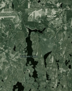
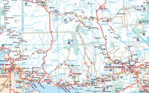
How To Get There: (see map and satellite photo below)
From Sudbury: Travel North (NW) on highway 144 towards Timmins. At the junction of highway 560 (the only gas station after Opaning (Sudbury)), turn left and go approximately 80 km west on a gravel road. The road is considered ‘private with public access’, meaning it’s an access road for the logging companies and the railroad. Although the road is gravel, it is mostly wide and in good condition. You will have no problem maintaining a speed of 80-100 km/h. Once you join up with highway 667 near the town of Sultan, the park entrance will be on the left about 10 km down the road.
From Sault Ste. Marie: Take highway 17 east out of the Sault for 80 to 90 km and turn left onto highway 129. Take 129 north for approximately 190 km until the junction of highway 667. Turn right or east on 667 and Wakami Lake will be on the right around 25 km down the road.
From Wawa: Go east of highway 101 for 130 km. Turn onto highway 129 going southeast for around 21 km. Look for highway 667 and do the same as above.
*** Once you leave highway 144 or highway 17, there are no gas stations, or society in general. For hours at a time on these highways, you might see a handful of other vehicles at most. Make sure you’re prepared!
Our Personal Take:
This was a long drive from Orangeville but it was exactly what we were looking for. We needed to get away from human kind and find a peaceful place in nature. Wakami Lake is definitely that. The only issue we had with the few other campers that were there was the use of generators at night. The park has a policy that says all generators must be turned off by 10 pm. I think they shouldn’t be allowed at all but my compromise would be to turn them off at 7 pm. There are so many sounds to hear in a place like this (including the sound of utter silence) and the opportunity is ruined by a family in an RV that has to have a stove cooked dinner while watching satellite TV.
Angie loves fishing. Angie only caught one baby perch. Why? Because we couldn’t get to the fish without a boat. Next time, the canoe will be on the roof. The rule of Wakami Lake is: if you need it – you better bring it.
If going – DO get a campsite on the water. Our site (54 – I think) allowed us to pitch the tent right on the small sandy beach, 3-4 feet from the waters edge.
The drive there shouldn’t be seen as an awful task. Don’t miss Onaping High Falls on the right side of the road, not far out of Sudbury. Take the gravel road from highway 144 on the way there and see how the logging industry works (clearcut, select cut, reforestation, etc.) and spot some wildlife (bears) you wouldn’t see on other roads. On your way back (even if you’re heading East) take 129 down to 17. This road is in great condition and mostly untravelled. The scenery is amazing with lush forest, rocky cliffs, beautiful lakes and the amazing Mississagi River that follows the road for a good portion of the last half of the highway.
Satellite image courtesy of Google Earth.
Map excerpt courtesy of the Ontario Ministry of Transportation.
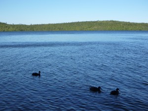
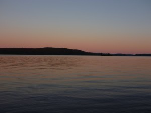
Click on photos to enlarge.


